ISRO is working on an ambitious project called Bhuvan (means Earth), a satellite mapping tool.
Bhuvan allows you to zoom far closer than the aerial view from a chopper. If Google Earth shows details upto 200 metres distance and Wikimapia upto 50 metres, Bhuvan will show images upto 10 metres, which means you can easily see details upto a three floor high building and also add information.
Bhuvan uses the data recorded by Indian satellites and the first prototype will be available by November.
Bhuvan’s edge over Google Earth
1.) Google Earth’s Zoom levels up to 200 mt ISRO’s Bhuvan Zoom levels up to 10 mt
2.) Google Earth: Single layer information ISRO’s Bhuvan: Multi-layer information
3.) Google Earth: Images upgraded every 4 years ISRO’s Bhuvan: Images upgraded every year
4.) Google Earth: No alternate viewing options ISRO’s Bhuvan: Options of viewing on different dates
5.) Google Earth: Uses international satellites ISRO’s Bhuvan: Uses Indian satellites
Bhuvan Vs Google earth (Comparision)
ISRO makes india proud launched BHUVAN
The Indian Space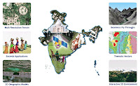 Research Organization (ISRO) has brought to the fore Bhuvan, a mapping application website like Google Earth, which is confident to give better 3D satellite images of India and provides India specific features.
What is the name of the word Bhuvan? Well, it means earth in Sanskrit and enables users to see any part of the subcontinent barring sensitive locations for instance military and nuclear installations. The 3D mapping tool makes use of images taken a year ago by ISRO’s seven remote sensing satellites, including Cartosat-1 and Cartosat-2. The satellites can even capture the images of objects as small as a car on a road.
What are its leading features?
These include Access, explore and visualize 2D and 3D image data along with rich thematic information on Soil, wasteland, water resources, superpose administrative boundaries of choice on images as required, visualization of AWS ( Automatic Weather Stations) data/information in a graphic view and use tabular weather data of user choice, Heads-Up Display ( HUD) naviation controls ( Tilt slider, north indicator, opacity, compass ring, zoom slider), navigation using the 3D view pop-up menu (Fly-in, Fly out, jump in, jump around, view point).
Apart from this the other features are drawing 2D objects (Text labels, polylines, polygons, rectangles, 2D arrows, circles, ellipse), drawing 3D Objects (placing of expressive 3D models, 3D polygons, boxes), snapshot creation (copies the 3D view to a floating window and allows to save to a external file).
DOWNLOAD LINK:
http://bhuvan.nrsc.gov.in/index.html


